Hile gunslingers,
so I have finally completed, organised, and released the official ChartingTheTower Maps of Mid-World and the Multiple Americas! (text continues below image …)
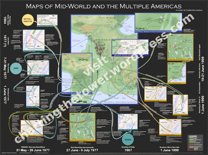
This map is much closer to what I originally imagined when I started working on the time line. I had planned on having a map of Mid-World in the middle (as shown here), with all the little maps of Manhattan and Maine and so on around it (as shown here), as well as all the time line information.
It soon became apparent that I was never going to fit all of that information on one image, and there seemed to be a lot of other people working on nice maps of Mid-World so instead I put my energies into creating the time line.
However, to me, none of the maps of Mid-World out there made sense. Now I appreciate that when “time is funny” and “the points of the compass are in drift” then really anyone can come up with any map of Mid-World and it can be considered reasonable. But I simply could not reconcile how an eight hour supersonic train ride could cover a similar distance to a couple of sick and dying men dragging each other up a beach for a week or so – which is how things are represented on some of the maps out there on the internet.
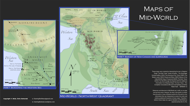
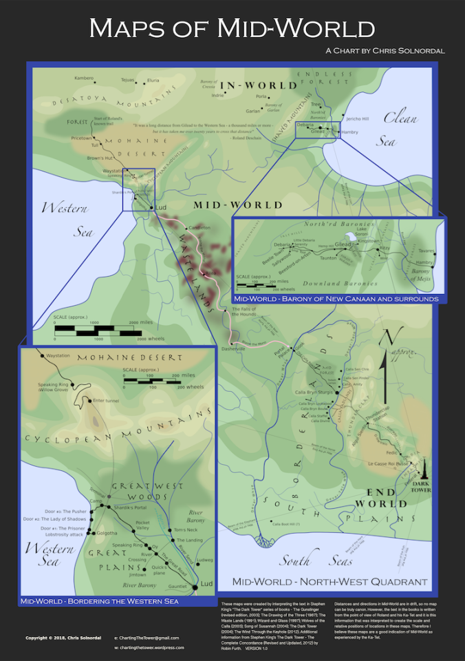
So, having finished the time line, I revisited the eight key texts of the Dark Tower series and compiled all the information I could about distances and times and directions. And from that I pieced together the basic structure of the main Mid-World map … to scale.
To make the scale work, I needed to use two insets, showing enlarged areas around the Lobstrosity Beach and also around Gilead and the Barony of New Canaan. Additionally, I had to explore the real world places mentioned in and around East Stoneham, and somehow create a version of Brooklyn which was the site of Co-Op City, Markey Avenue, and the Dutch Hill Mansion.
Another rule I gave myself was that if a place was mentioned, but no indication is given of where it actually is, then I did not include it on the map. Some descriptions are only very vague and guesswork was obviously involved. However, if no indication of location is given then I left it off. Probably the vaguest clue that I actually went with was this quote from Wolves of the Calla:
“They backed away in a hurry, as if expecting the two out-worlders carrying guns to immediately slap leather and blow sai Took all the way to Calla Boot Hill.”
From this is it clear that Calla Boot Hill is a long way from Calla Bryn Sturgis, so I have positioned it about as far away from there as it could possibly be, whilst still being in the Borderlands.
As a check on locations, I went through all locations listed in Robin Furth’s excellent Dark Tower Compete Concordance. This also helped me with some of the references from The Little Sisters of Eluria – which I only have on audiobook, so it was difficult to quickly find details of places mentioned in that story.
After a great deal of calculating and sketching and drawing on my computer, I came up with the image above. You can get a closer look at it here or purchase a high resolution poster from my Etsy store here.
I have also made a downloadable version just of the Mid-World part of the maps, which is optimised for a standard 1920 x 1080 pixel screen here. It looks like this: –
Finally, you can also get posters of Mid-World only at the store. They look like this: –
I hope you like my Maps of Mid-World and the Multiple Americas. Like I said, there are a lot of them out there, but I think I’ve come up with what is close to a definitive one.
Long days and pleasant nights,
Chris
